Sardis Lake Recreation

Do you remember the line from the movie Field of Dreams, “If you build it, they will come”?  At Sardis Lake you can see that phrase in action.  Sardis was built as a flood control facility in the 1930s and recreation was not mentioned in the original plans.  Soon after the Dam’s construction, however, visitation skyrocketed.  Today, recreation management is a priority right along side flood risk management and environmental stewardship.  The employees of Sardis Lake take great pride in building and maintaining some of the top recreation facilities in the country. 

Whether planning a one day outing or an extended camping trip, you can find a wealth of activities to fill your days and nights.  Come camp in one of our modern campgrounds, picnic, swim, rent a pavilion for a family reunion or find a spot somewhere on our 98,000 acres to boat, hunt, fish, go birding, or walk a trail.  It’s your lake, come and enjoy the natural beauty of Sardis Lake.


                                      Sardis Lake Brochure                                                          Sardis Lower Lake Map with Pavilions

Day Use Areas

Sardis Lake has numerous day use areas which are designed to accommodate our ever-increasing number of daytime visitors.  If your plans for the day include a picnic, our day use areas offer a table, pedestal grill, and a service table at each site.  After a good meal, there will be plenty of other amenities located nearby, including playgrounds, boat launching ramps, fishing areas, restrooms, beaches and picnic shelters.  Our picnic shelters are ideal for large groups and comply with Americans with Disability Standards (ADA), and can be reserved for $50 per 1/2 day or $100 for the full day (8:00 am to 9:00 pm). Call (662) 563-4531 for reservation information.

Day Use Fees:
Boat Ramps-$5 per day
$2/walk-in, $5/vehicle, $20/bus. No fees for children under 16
Annual Pass for Day User Fees - $40

Sardis Lake Brochure Map 

Picnic Areas

Area
Picnic Sites
Lower Lake
250
Engineer Point
46
Beach Point
14
Cypress Point
17
Clear Creek
68
Graham Lake
6
Hays Crossing
5

Group Pavilions and Mini Shelters 

Pat’s Bluff, Paradise Point Pavilions, Lower Lake Pavilions at Cypress Point, Riverside and Big Acres, Engineer Point, Clear Creek # 1, Clear Creek # 2, Main Beach Mini Shelters, Outlet Channel North Side, Mini Shelter Little Acres

Sardis Lower Lake Map with Pavilions

 Sardis Lake Boat Ramps

Engineer Point
Cole's Point
Pat's Bluff
Clear Creek
Coontown
Hurricane Landing
Wyatt Crossing

Teckville                                                                                                                                                                                                             Lower Lake ADA Accessible Dock and Boat Ramp                           

Playgrounds

Cypress Point, Big Acres, Paradise Point, Hurricane Landing

Trails

Sandstone Nature Trail, Sandstone Fitness Trail, Clear Springs Nature Trail and Clear Creek Mountain Bike Trail

Beaches

Lower Lake

Cypress Point
Paradise Point
Main Beach

There are no designated beaches on the upper lake.


Life Jacket Loaner Boards are located at all of Sardis Lake's swimming beaches. We encourage visitors to borrow a jacket for a day and wear it while swimming. When you are finished, please return it to the board for others to use. Remember - your safety is our concern!

Fishing

Just about everywhere!

Additional Facilities

Covered Benches North and South Outlet Channel, Arty Tapp Memorial Overlook, Paradise Point Basketball Court

Also located at Sardis Lake is John Kyle Sate Park and Golf Course located on the North end of the Dam and the Sardis Lake Marina located on the south end of the dam.

Sardis Lake brochures are available upon request at the Sardis Lake Office or by calling 662-563-4531.

Know the Rules!  Review Title 36. Part 327, Rules and Regulations Governing Water Resources Development Projects.

Camping

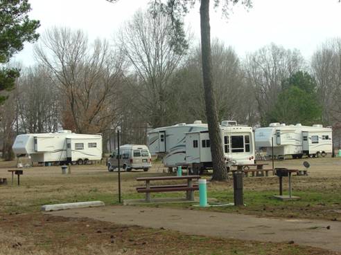
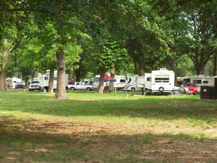
Sardis offers a wide array of camping opportunities, whether you are traveling in an RV, packing a tent, or looking for something primitive,
we have you covered. We maintain 9 campgrounds located around the Lake as well as campgrounds, group camps and cabins located at John Kyle State ParkOur campgrounds offer a host of amenities such as restrooms, showers, boat ramps, sanitary disposal systems, playgrounds, electric and water hookups, and beaches. 

Sardis Lake Brochure Map 

CLASS A CAMPGROUNDS

Amenities at our Class A Campgrounds include waterborne toilet/showers, water/electrical hookups, and a sanitary disposal station.

Clear Creek:  52 campsites FEES $24.00 per night year round

Location: I-55, take exit 243-A in Batesville, MS and travel 21 miles east o MS Highway 6 towards Oxford, MS. Turn left at West Oxford exit onto West Jackson Avenue and travel approximately 3 miles. Turn left onto MS highway 314 and travel Approximately 13 miles to Clear Creek Recreation Area.

Clear Creek Campground Map

Oak Grove:  82 campsites FEES $24.00 per night year round

Location:  From I-55 take exit 252 or 246 and travel to Sardis Dam.  Campground is located about midway of the Dam on the Lower Lake.

Oak Grove Campground Map


Hurricane Landing - 19 sites FEES $24.00 per night year round

Location Take Hurricane Landing Road west at Abbeville exit off of MS HWY 7 and travel approximately three miles.

Pat's Bluff Campground - 16 sites FEES $24.00 per night year round

Location: Take Sardis Lake Dam Exit and travel approximately 1 mile. Turn on Sardis Lake Drive and travel approximately 5 miles.

CLASS C CAMPGROUNDS

Amenities at our Class Campgrounds include waterborne toilets and primitive camping, fire ring, service table and grill.

Beach Point - 14 campsites

Location: From I-55 take exit 252 or 246 and travel to Sardis Dam.  Campground located on north end of Dam on the Upper Lake.

Fees:  $8 per night April 1 - September 30, free in the off season.  All campsites are non-reservable and are available on a first come – first serve basis.

Sleepy Bend - 50 campsites

Location: From I-55 take exit 252 or 246 and travel to Sardis Dam.  Campground located on north end of Dam  on the Lower Lake.

Fees:  $10 per night April 1 - September 30, free in the off season.  All campsites are non-reservable and are available on a first come – first serve basis.

Class D Campgrounds

Amenities at our Class D Campgrounds include a tent pad, service table and grill.

Clear Creek - 10 campsites

Location: I-55, take exit 243-A in Batesville, MS and travel 21 miles east o MS Highway 6 towards Oxford, MS. Turn left at West Oxford exit onto West Jackson Avenue and travel approximately 3 miles. Turn left onto MS highway 314 and travel Approximately 13 miles to Clear Creek Recreation Area.

Fees:
These campsites are free and are non-reservable. They are available as first come – first serve.

Park Rangers are on duty at Sardis Lake throughout the year and can answer any additional questions you may have. The Sardis Lake Field Office and Visitor Information Center is open M-F from 7 am - 3:30 pm (excluding Holidays). The office can be reached at 662-563-4531. Sardis Lake brochures are available upon request.

Boating

Can’t wait to get on the water?  Sardis Lake offers two premier lakes for your boating enjoyment.  Come ski, tube, pontoon, sail, fish or just cruise on our ever popular 425 acre Lower Lake or our renowned 32,000 acre Upper Lake (summer pool).  

Sardis Lake makes it is easy to get on the water with 11 launching ramps on the Upper Lake and one on the Lower Lake.   

Sardis Lake Boat Ramps & Elevations for Launching* 


Elevation Elevation
Boat Ramps  Upper End Lower End
Beach Point 281.00  239.00
Clear Creek  275.25   237.25
Coles Point 269.00   234.00 

Coontown

   
 No. 1 269.00   258.00 
 No. 2  260.00    250.00 
 No. 3 252.00   242.00 
 No. 4 244.00  239.00
Engineer Point    
 High Water  275.00    250.00 
 Low Water 265.00   234.00 
Frank Walker Landing  **  **

Graham Lake

 276.40   264.40
Hurricane Landing    
 No. 1  269.00    258.80 
 No. 2 262.00  249.40
 No. 3 Indian Mound  250.00    240.00
Lespedeza Point  269.00   240.00
Lower Lake  211.40   193.50
Pat's Bluff 277.40  234.00
Teckville    
No.1 282.00 258.00
No. 2   248.00
No. 3   244.50
No. 4   238.50
No. 5   238.50
Wyatts Crossing    
 No. 1 270.60   264.50
 No. 2 266.50   255.80
 No. 3 259.00   251.00
 No. 4 253.00   243.00


*Launching Fees are $5 or you can get an annual pass for $40

**Frank Walker Landing is located on the Tallahatchie River.  The elevation of the river is higher than the lake, so you are able to launch at lower lake stages. 

Sardis Lake brochures are available upon request at the Sardis Lake Office or by calling 662-563-4531.  A downloadable map is available at the link below.

Sardis Lake Brochure Map 

Helpful Links:

Sardis Lake Marina - http://www.sardismarina.com/

State of Mississippi Fishing Regulations - www.home.mdwfp.com/fishing


Boating Safety

Many boating accidents and fatalities could be prevented if people on board would wear their life jackets and if they would not drink and boat.  Many collisions could be avoided if the operator paid full attention and avoided risks.  Know the rules for small water craft and remember to wear your life jacket.   BOAT SMART - BOAT SAFE!


Trails

Fitness/Nature Trails

Sardis Lake has several trails designed for short leisurely hikes.  Close to the Dam you will find the Sandstone Nature Trail. This trail gently stretches over a mile and a half of upland hardwood-pine mix.  Sharing the same trail head is the Sandstone Fitness Trail providing a challenging two mile course with frequent workout stations.  On the opposite end of the Dam is the Clear Springs Nature Trail.  This trail offers an excellent opportunity to view upland hardwoods and a cypress swamp all on one trail. 

Sandstone Nature Trail and Sandstone Fitness Trail

Clear Creek Bike Trail

Sardis Lake now offers a 13 mile mountain bike trail located on the south side of the lake at Clear Creek Recreation Area near Oxford, Mississippi.  The Clear Creek Mountain Bike Trail offers  three connecting loops of wonderful scenery and some moderately challenging terrain that are not very common in this part of North Mississippi. The trail is open to the public and will hopefully be the future site of mountain biking events such as the Clear Creek Challenge. Sardis Lake Park Rangers would like to remind everyone visiting the trail to always wear a helmet, read safety rules posted at the trailhead, and always ride safely. For more information please contact the Sardis Lake Field Office at (662)563-4531.

Clear Creek Mountain Bike Trail Map

Sardis Lake Arboretum

Sardis' Lower Lake area is the home of the Sardis Lake Arboretum.  Whether you walk or ride from location to location, this trail is a great way to tour the Lower Lake area while learning about the various types and species of trees that have become a part of the scenery that gives the Lower Lake area a beautiful and pleasing aesthetic value.  A map of the trail is provided for your convenience using the link below.  A brochure booklet is available at the Sardis Lake Visitor Information Center. 

Sardis Lake Arboretum Map

While walking or riding a trail don't forget to observe the wildlife!

Hunting & Fishing

Hunting

Sardis hunting areas offer a wide mix of habitat that include forested areas with pine, hardwood, and pine/hardwood mix, open fields and wetlands.  These areas offer an abundant source of food and cover for the wildlife that is indicative of this region. Additionally, wildlife food plots are planted and maintained yearly at Sardis Lake.  These areas provide nutrition for White-tail deer, Bobwhite quail, Eastern wild turkey, migrating waterfowl species, rabbit, dove, raccoon and squirrel.  Some of the planted crops species are sorghum, soybeans, chufa, millet, clover, wheat and corn.

Hunting and Fishing regulations to include license procurement, seasons, and limits are set and enforced by the Mississippi Department of Wildlife, Fisheries and Parks. For complete and up-to-date information visit the MDWFP web site at http://home.mdwfp.com.

WALK IN AND SHOOT


What exactly is a walk-in hunting area?  It is an area where only hunting on foot is permissible.  The Sardis walk-in hunting area comprises 3,840 acres within 42,274 acres of the Upper Sardis Wildlife Area in northeast Lafayette County and is jointly owned by the US Forest Service and the US Army Corps of Engineers. There are two walk-in only hunting areas on Sardis Lake. For a complete look at all hunting areas on Sardis Lake check out the Sardis Lake Brochure.  To obtain a brochure, stop by the Sardis Lake Field Office or call 662 563 4531.

Hunting & Fishing Map 

Archery Only Hunting Map


Fishing

Sardis Lake offers one of the best fishing opportunities in the South East.  Anglers from around the country annually make the trek to fish our beautiful 32,000 acres. We provide the optimal opportunity to get away from the hustle and bustle, with limited shoreline available to the public for development you can get back to nature somewhere along the miles of uninhabited shoreline. Set back and relax as you plan your strategy on how to catch a largemouth bass, crappie, or catfish.  Come join us each January when we place more than 1,000 Christmas trees on the lake bed for artificial fish habitat.  It provides great coverage for the fish and keeps the trees out of the landfill.  Launch your boat at any of our 8 ramps located around the lake for easy access and remember to wear your Life Jacket!
 
Fishing tournament organizers are reminded that a Special Event Permit is needed for tournaments larger than 10 boats. A Special Event Permit can be obtained by contacting the Sardis Lake Field Office at 1-662-563-4531.


Additional information that may be helpful when planning your next fishing trip:
Navigational and topographic maps (available at area stores and marinas) 
Sardis Lake Brochure available at the Sardis Lake Office (Phone: (662) 563-4531.

Sardis Lake Brochure Map 

Hunting & Fishing Map

Mississippi State Fishing Regulations
http://home.mdwfp.com/fishing.aspx


Park Rangers are on duty at Sardis Lake throughout the year and can answer any additional questions you may have. The Sardis Lake Field Office and Visitor Information Center is open M-F from 7 a.m. - 3:30 p.m. excluding Holidays. The office can be reached at (662) 563 4531.