USACE Vicksburg District to offer daily, annual day use passes online for Mississippi lakes
VICKSBURG, Miss. -- The U.S. Army Corps of Engineers (USACE) Vicksburg District announces that Arkabutla, Sardis, Enid and Grenada Lake visitors can purchase daily and annual day use passes online.
Beginning mid-June, visitors will be able to purchase activity passes for boat ramp and swimming area use through the website www.recreation.gov or the Recreation.gov mobile app (available through the App Store or Google Play).
Visitors can purchase passes in the recreation areas by scanning QR codes on signs or from anywhere using computers, mobile devices, and smartphones. Visitors that purchase annual passes will have 14 days to visit any of the Mississippi lakes field offices to receive the physical hang tag for that pass.
The activity passes expand Recreation.gov opportunities at the Mississippi Lakes. Camping and picnic shelter reservations at each of the lakes are also made through the service. For many years, payment for these activities has been cash-only through the use of honor vaults in the areas. With the increased use and security of mobile payments, alternatives to cash are becoming preferred methods. Honor vaults will be removed once the QR code system is implemented and monitored to make sure it functions as needed. Cash payments can still be made for daily and annual passes, as well as America the Beautiful passes at each of the field offices.
For more information, please contact the north Mississippi lakes field offices:
Arkabutla Lake: 662-562-6261
Sardis Lake: 662-563-4531
Enid Lake: 662-563-4571
Grenada Lake: 662-226-5911
The USACE Vicksburg District is engineering solutions to the nation’s toughest challenges. The Vicksburg District encompasses a 68,000-square-mile area across portions of Mississippi, Arkansas, and Louisiana, that holds nine major river basins and incorporates approximately 460 miles of mainline Mississippi River levees. The Vicksburg District is engaged in hundreds of projects and employs approximately 1,100 personnel.
XXX
FISH STRUCTURE PLACEMENT REGULATION
All persons placing structure(s) in Sardis, Arkabutla, Grenada, and Enid lakes must abide by the terms outlined in the following regulations according to U.S. Army Corps of Engineers (COE) Title 36.
The placement of untreated, wooden structures in the lake basin for the purpose of fish habitat is authorized. Artificial wooden "grabbling structures" are also authorized. Natural structures may not be altered and used to "hand fish" from. Other structures made of plastic, PVC, metal, and other non-biodegradable materials are NOT allowed. Any person(s) installing a structure not in compliance with this regulation may be subject to a citation under Title 36.
The placement of trees are allowed along with an appropriately sized anchoring device which may be made of concrete, brick, or stone. Any anchor(s) other than these approved materials will be in violation and subject to fines and penalties.
Structures may not be placed within 300 feet of any designated swimming area or beach. These structures should not be placed in any areas where they may become boating hazards such as directly below or adjacent to any boat ramp.
Life Jackets are Mandatory at MS Lakes
The following life jacket rules are being enforced at all four of the Vicksburg District-North Mississippi lakes at Arkabutla, Sardis, Enid and Grenada.
All persons must wear a US Coast Guard-approved life jacket at all times:
- while swimming outside of designated swimming areas.
- while skiing or being pulled by a vessel, regardless of vessel length.
- on powered vessels 16 to 26 feet in length whenever under power by the main propulsion unit.
- on powered vessels less than 16 feet in length or on non-powered vessels regardless of length.
For more information, contact the Grenada Lake Field Office at 662.226.5911 or the MS Project Management Office at 662.578.3873 or 662.712.1201.
RULES FOR SAFE OPERATION OF OFF-ROAD VEHICLES AT ARKABUTLA, SARDIS, ENID, AND GRENADA LAKES. CLICK HERE!
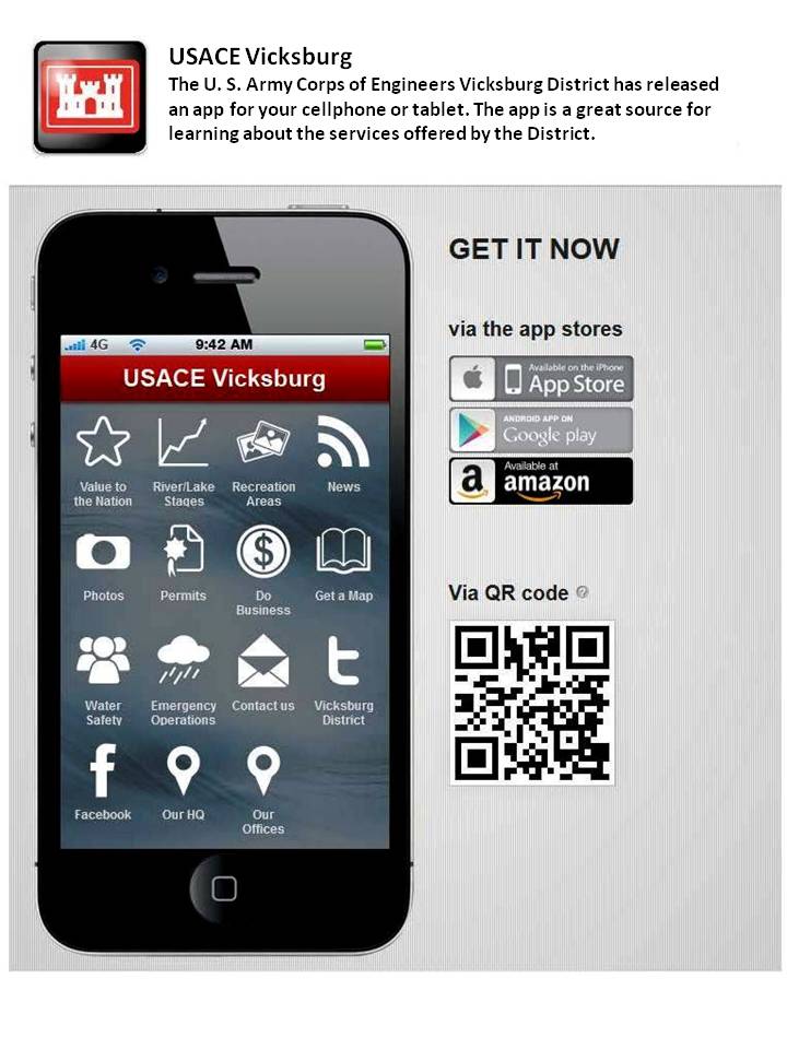
The Vicksburg District has a new APP!
The app is a great source for learning about the services offered by the District. Here are some of the items contained in the app:
• Water level observations for the District and forecasts from the National Weather Service
• Info on how to sell your goods and services to the Corps of Engineers
• Social media, news and photos from the District’s Public Affairs Office
• Info from the District’s Emergency Management Office for times of crisis
• Permitting info and notices from our Regulatory Office
• Tons of info on all of the recreation areas in the District
• Free map downloads of maps of major rivers including the Mississippi
• Ways to find our offices in the District and contact us here at HQ