 The Vicksburg District traces its history back to 1873 when Capt. William Henry Harrison Benyaurd opened a U.S. Army Engineer office in Monroe. The new office was primarily concerned with surveys and removal of wrecks and other navigational hazards in the Yazoo River in Mississippi and the Ouachita River in Louisiana following the Civil War.
On June 28, 1879, an Act of Congress created MRC to direct all work on the Mississippi River.The same act provided for U.S. Army Corps of Engineers districts to do the work.
 On August 1,1884, Capt. Eric Bergland established the first permanent Engineer office in Vicksburg. However, this office had no responsibility for work on the Mississippi River. Since Bergland, the district has had nearly 50 district engineers.
In the 1890s, the United States was divided into five Engineer Divisions, and the Vicksburg office was placed in the Southwest Division. Vicksburg was later transferred to the Gulf Division headquartered in New Orleans and, in 1909, was transferred to the Western Division headquartered in St. Louis.
In 1929, the Western Division was reorganized into the Upper and Lower Mississippi Valley Divisions, and LMVD was headquartered in Vicksburg. It supervised the work of three Engineer Districts-Memphis, New Orleans, and Vicksburg.
During its more than 100 years in the area, the Vicksburg District has been responsible for a wide range of activities, including shortening the river by more than 100 miles, building seven flood control reservoirs, returning navigation to the Red and Ouachita Rivers, standardization of 1,758 miles of levees, and returning navigation to the port city that serves as its headquarters.
In the early days of flood control, Corps levee construction was limited to areas where it improved navigation. It was because of this requirement that the Vicksburg District was able to aid local levee boards in the Mississippi Delta in the early 1900s.
With the Ransdell-Humphreys Flood Control Act of 1917, the Federal Government committed itself to flood prevention and control. The act appropriated $45 million to the MRC, to be spent $10 million a year, and required local interests to pay at least half the cost of flood protection works and provide all levee rights-of-way.
At the turn of the century, the Vicksburg Engineer office also assumed a major portion of the responsibility for construction of the Vicksburg National Military Park, commemorating the siege of the historic hill city.
A system of six locks and dams on the Ouachita River to provide year-round 6-1/2-foot navigation to Camden, Arkansas, became the first major navigation project for the office in the early 1900s. The work was completed in 1924 at a total cost of $4.5 million, making it the cheapest canalized waterway in the nation.
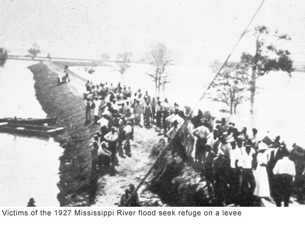
In 1927, the Lower Mississippi Valley was literally swamped by one of the worst floods on record, and the Vicksburg District was caught in the middle. Much of the land along the Mississippi and its tributaries was protected by levees, and only by levees. The district was responsible for
  watching 420 miles of these levees, and the innovative Maj. John C. H. Lee brought in Navy seaplanes to patrol the levees for signs of weakness. Despite all efforts, levees along the Arkansas and Mississippi Rivers broke, flooding large areas of Arkansas, Mississippi, and Louisiana. Losses from the flood in the Vicksburg District were estimated at about $104 million.
With the Flood Control Act of 1928, the district became involved in a comprehensive flood control program, which eventually included lakes, levees, and other measures. Following the 1927 Flood, it was realized that, while levees were indispensable, to depend on them for flood protection was suicidal. A plan developed by Lt. Gen. Edgar Jadwin called for floodways, spillways, levee improvements, channel stabilization, mapping, and a navigation channel, a system capable of safely passing the worst possible flood in the valley.
 Jadwin's plan was not written in stone, but allowed modifications to accommodate the developing river over the years. The plan called for at least one floodway in the Vicksburg District, but it was never built. Instead, a cutoff program proved so beneficial that the floodway was dropped, and 14 cutoffs were made, shortening the river by 152 miles. Cutoffs allow the river to pass increased flows more quickly.
While Jadwin's plan ruled out flood control reservoirs on the Mississippi's main stem, he advocated studying them for the tributaries as part of the comprehensive plan for developing all water resources. In 1936, the Yazoo Headwater Project, pushed by Congressman Will M. Whittington of Greenwood, Mississippi, became a reality and resulted in Arkabutla, Sardis, Enid, and Grenada lakes.
Construction was begun on Sardis Lake in 1936 and, in 1940, the project became operational. Sardis Dam is a hydraulic-fill dam, one of the earliest of its kind in the nation. Work was begun on Arkabutla Lake on the Coldwater River immediately after completion of Sardis. The dam was built between 1940 and 1943 to control the runoff from 1,000 square miles of surrounding hill country. Arkabutla was followed by construction of Grenada and Enid dams, but completion of these two structures was delayed by World War II.
Three similar lakes were built about the same time on the headwaters of the Ouachita River in Arkansas-Ouachita, DeGray, and Greeson. In addition to flood control, the three Arkansas lakes were designed for hydropower production. In the early 1950's, work was begun on the first of the three Ouachita River Lakes. Narrows Dam at Lake Greeson on the Little Missouri River, the only concrete dam constructed in the Vicksburg District, was the first of three multipurpose flood control dams built in Arkansas. Narrows was followed by Blakely Mountain on Lake Ouachita in 1955 and by DeGray on the Caddo River in 1970.
In 1960, the Corps began the Flood Plain Management program to provide floodplain management assistance, upon request, to local, state, and other federal agencies, including the Federal Emergency Management Agency, Farmers Home Administration, Federal Housing Administration, and the U.S. Postal Service.
The construction inspection services of the Vicksburg District were contracted out to the Environmental Protection Agency (EPA) in 1978 to oversee construction of federally funded wastewater treatment plants throughout Mississippi.
In the early 1980s, the Vicksburg District went international, with a water resources development study in the Niger Basin of West Africa. Also, engineers from other nations have come to the Vicksburg District to study the way we do business.
Since the Engineers first opened an office in Vicksburg, the work and responsibility of the district have grown and diversified. From simple clearing and snagging operations on two small rivers in Mississippi and Louisiana, the mission of the Vicksburg District has grown to an annual program regularly exceeding $200 million and work responsibilities with international impacts.
Flood control structures, such as Steele Bayou Structure near the confluence of the Yazoo and Mississippi Rivers, and pumping plants, such as Tensas-Cocodrie on the Black River in Louisiana, have been built allowing water to pass outward while preventing rising stages from backing through the levees.
But even with all of the work accomplished to date, the war is not necessarily won. Local levee boards work constantly to ensure that the levees and drainage structures are ready to meet any high- water emergencies. The Vicksburg District continues to work closely with local boards, providing technical assistance and advice and, in emergencies, men and equipment. Flood protection is a partnership between Federal, state, and local governments.