 Environmental stewardship is the responsible use and protection of our natural environment through conservation and sustainable practices. The Corps of Engineers is committed to the preservation of the resources that are under its authority and, it is through responsible planning and management techniques that the staff at Enid Lake accomplishes that task. However, with over 44,000 acres of forest and wetlands which make up the Enid Lake Project, it is imperative that we all do our part to preserve and protect Enid Lake's natural environment. By teaching environmental principles through outreach programs, special events, and volunteer efforts, Enid's staff is helping to ensure her natural resources will be available for future generations to experience and enjoy. A few of our more popular events are listed below.
Habitat Day
 Habitat Day activities began in 1990 as a result of concerns about the loss of fish structure in the lake due to the process of aging and inundation. The Corps of Engineers joined forces with a local Bass Club to begin replacing lost habitat with cedar tree shelters. Since that time, Habitat Day has become an annual event with increased numbers of participants and shelters each year.
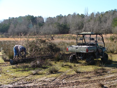
Clean Up Day
Clean-Up Day began in 2004 as a result of concerns about the amount of litter and rubbish that had accumulated on the shoreline and roadways around the lake. The Corps of Engineers partnered with citizens of local communities surrounding the lake and planned an annual event that would set aside one day committed to picking up trash and rubbish to restore and maintain the beauty of Enid Lake.
World Water Monitoring Day
World Water Monitoring Day is held every fall during the month of October. During the event, students from local schools visit Enid Lake to participate in water quality studies. Studies includes: water sampling, analyzing data, and reporting results to a national water quality data base. During the day students are educated about the value of clean water to our environment, and the importance of protecting our natural resources.
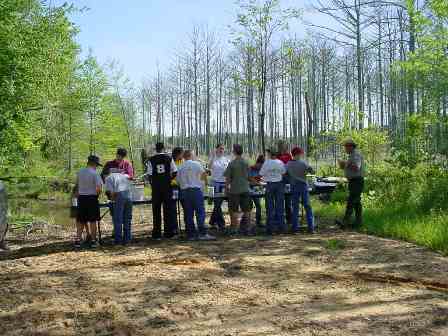
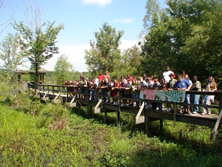 Environmental Awareness Day
Environmental Awareness Day, formally known as National Earth Day, is a globally celebrated event. It is an annual observance held to increase public awareness of environmental issues and to encourage support for clean air, clean water, and clean land. Each year the Corps of Engineers provides various stations for local school groups to visit. Rangers address issues on land use, forestry, wetland management and wildlife.
Recreational Stewardship Practices (Tread Lightly)
- Travel Responsibly - Stay on designated roads, trails and recreational areas.
- Respect the Rights of Others - This includes land owners and other users of the land or water where you are recreating.
- Educate Yourself - Plan your trip, learn the rules of an area, take recreational skills classes and know how to operate your equipment safely before you arrive.
- Avoid Sensitive Areas - examples: meadows, lakeshores, wetlands and streams. Do not disturb historical, archeological or paleontological sites. Do not operate watercraft in shallow waters or near the shorelines at high speeds.
- Do Your Part - Model appropriate behavior, leave an area better than you found it, properly dispose of waste, minimize the use of fire, avoid the spread of invasive species, and repair degraded areas.
For more information about Tread Lightly, visit their website at www.treadlightly.org
IMPORTANT NOTICE TO ENID LAKE PATRONS
The winter drawdown of Enid Lake exposes thousands of acres of mudflats. Exploration of these mudflat areas is a popular recreational activity for many lake visitors. While the Corps encourages visitors to enjoy this activity, they ask that visitors keep safety and resource protection in mind. Mudflat areas provide a variety of interesting and unique features but also present a number of hazards to those who choose to explore them. When traveling across the open mudflat areas, visitors are encouraged to use caution and be observant of hazards such as trot-lines, dead timber, sinkholes, etc.
Over the past several years, the recreational sport of All Terrain Vehicle (ATV) riding has become increasingly popular at Enid Lake. Riders are encouraged to participate in Tread Lightly! This is an educational program dedicated to increasing the public's awareness of how to enjoy the great outdoors while minimizing the impacts of recreational use.
Even though ATVs were built and designed for the effective navigation of rocky, muddy and root-covered terrain, the US Army Corps of Engineers at Enid Lake challenges all ATV riders to be environmentally conscious and to practice the principles listed above when visiting Enid Lake. The misuse of ATVs can cause rutting and destroy sensitive wetland habitat, erode creek banks, and even destroy native species allowing invasive plant species to take over. Streambed riding is PROHIBITED as it damages and destroys the sensitive aquatic life of both plants and animals that are important to our ecosystems.
Visitors should also be aware the destruction, defacement, removal, or any alteration of public property including natural formations, mineral deposits, historical and archaeological features (material from old house sites, arrowheads and other Native American artifacts, etc.) and paleontological resources (Native American remains) are illegal and therefore prohibited.
Each visitor comes to enjoy something different; yet there is one common goal and that is to enjoy and utilize Enid Lake and its natural resources. With this in mind, visitors are reminded the public lands surrounding Enid Lake are for everyone's enjoyment and it is the responsiblity of each visitor to protect and preserve its resources, respect others and to obey all rules and regulations.