Stewardship can be defined as the personal responsibility for caring for another individual’s property.  In our case, environmental stewardship can be looked upon as the U.S. Army Corps of Engineers at Arkabutla Lake and local stakeholders jointly caring for the environment for our Nation’s present and future generations. Environmental stewardship incorporates both hands-on and passive management techniques in order to sustain healthy ecosystems, biodiversity, and conserve natural resources so the conditions of our lands and waters will be left in an equal to or better status than when they were first acquired.
We serve as the stewards of the lands and waters at the Arkabutla Lake Project. Environmental stewardship has always been an essential component between the U.S. Army Corps of Engineers at Arkabutla Lake and the citizens of the lake’s surrounding communities. Working alongside local citizens, Federal, State, and local agencies and groups, there is a continuous effort to improve upon the quality of the natural and water resources of the Arkabutla Lake area.
The US Army Corps of Engineers is the steward of nearly 12 million acres of public lands and waters. The mission of the program is to manage and conserve natural resources consistent with ecosystem management principles, while providing quality public outdoor recreation experiences to serve the needs of present and future generations. The management of natural resources by utilizing a stewardship concept ensures the conservation, preservation, and protection of Corps land and water resources.
Environmental Stewardship at Work
Arkabutla Lake NRM personnel promote Environmental Stewardship goals through the use of many special events throughout the year that encourage participants to learn more about their environment and through the establishment of wildlife management areas. Some of the events include: special wildlife management hunts for deer and raccoon, Outdoor Education Day, Adopt-A-Stream, Fish Habitat Day, Mid-Winter Bald Eagle Survey, other frequent wildlife population and vegetation surveys, and several outreach interpretive/educational programs pertaining to Mississippi’s native flora and fauna.
Adopt-A-Stream: The Adopt-A-Stream program is one of our most successful programs. 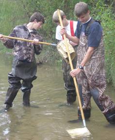 This environmental awareness program which began in 1998 involves partnerships with local schools. Each month students collect chemical and biological data and report their findings to the Mississippi Department of Environmental Quality. The students also pick up litter, plant trees, and care for the general area around the streams.
Fish Habitat Day: Every year around January the staff at Arkabutla Lake promotes Fish Habitat Day. This event 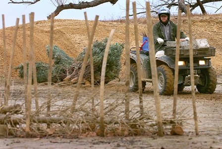 requires the cooperation of lake employees, local volunteers, and local businesses’ contributions that are vital to the success of this annual event. While lake employees and local volunteers actually place the habitat structures throughout the lake bottom; local businesses furnish the much needed supplies such as Christmas trees and stakes. The donated Christmas trees and stakes are placed in various areas within the lake bottom that typically don’t have any natural structures for fish to utilize as protective cover from predators, areas to feed around, or spawn. These three needs are provided by the placement of Christmas trees and stakes in the lake bottom while vastly improving the quality of fish and the fishing experience at Arkabutla Lake.
Mid-Winter Bald Eagle Survey: The purpose of the Midwinter Bald Eagle Survey is to monitor the status of Bald Eagle wintering populat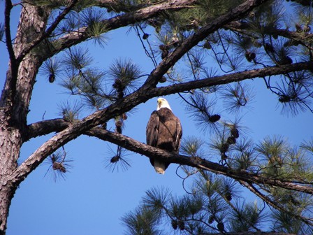 ions in the United States by estimating national and regional count trends. Each January, several volunteers and Arkabutla Lake employees monitor various areas around the lake and tally the number of Bald Eagles identified. The information collected is sent to the U.S. Geological Survey to include in the National Mid-Winter Bald Eagle Survey.
Outdoor Education Day: In conjunction with National Public Lands Day, the annual Outdoor Education Day 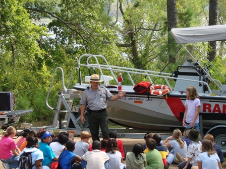 at Arkabutla Lake serves to educate local youths about important environmental and natural resources issues. The event has helped to build partnerships between the local community, other Federal and State agencies, and other organizations that share a common interest in the enhancement and restoration of the public lands at Arkabutla Lake for outdoor recreation and conservation. Topics of discussion during the event include learning about the importance of conserving water, reducing pollution and energy wastage, recycling, forest conservation, soil conservation, learning about native flora and fauna, water/boating safety, and hunting safety.
Outreach Interpretive/Educational Programs: For decades the staff at Arkabutla Lake has educated local citizens through outreach programs. These programs vary from interpretive/educational topics about Mississippi’s native flora and fauna to boating and water safety. Every year thousands of people are enlightened through these programs. The programs often take place at local schools, churches, and even at the swimming beaches at the lake.
Senatobia Wetlands Project
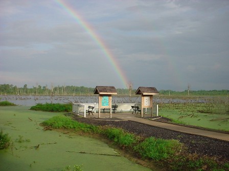 The Senatobia Wetlands project was created as a cooperative effort between the U.S. Army Corps of Engineers, Tate County Economic Development Foundation, and Duck’s Unlimited in an effort to revitalize a declining wetland area. Restoring the wetland area includes conducting continuous environmental research while also managing fish and waterfowl populations. It is also an aesthetically pleasing area where visitors can sit down and observe wildlife and waterfowl in the wetland area. There are interpretive educational panels located at the observation site that list some of the animals and waterfowl one might see while overlooking the wetlands.
Askew Wildlife Management Area
In 1943, the U. S. Army Corps of Engineers-Vicksburg District purchased the Askew Wildlife Management Area as part of the Yazoo Headwaters Flood 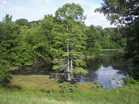 Control Project. The authorized project purpose of this land was to serve as a water detention basin. This area was expected to control excessive or peak runoff from uncontrolled drainage areas located below Arkabutla Dam. The frequently flooded property later became a part of a mitigation plan for the Yalobusha River and Tallahatchie River channel maintenance projects located in the Yazoo Basin of Mississippi.
The main objective for the area was to provide an effective bottomland ecosystem that was capable of supporting similar habitats and wildlife populations that existed prior to the channel manipulations that occurred in the Yazoo Basin. The alternative was to reforest 980 acres and develop approximately 400 acres of moist soil areas at Askew as a result of an environmental analysis based on an environmental assessment completed during April of 1994. This mitigation alternative was completed in 1996.
Management of the property is performed by the U. S. Army Corps of Engineers-Arkabutla Lake Field Office. The area consists of approximately 4,305 acres of bottomland habitat located within the Lower Mississippi Alluvial Valley. The area requires an adaptive management approach, which will allow certain management practices and techniques to be changed in response to changes in plant and animal populations.  Existing habitats in the management area include bottomland hardwoods, moist-soil areas, forested wetlands, transitional bottomland hardwoods, open-aquatic and riverine systems. In 2003 Ducks Unlimited and the U.S. Army Corps of Engineers formed a partnership to improve the area’s waterfowl habitat. A large portion of the area is dedicated to the management of waterfowl by implementing the use of moist soil management areas and green tree reservoirs.
These practices have greatly enhanced waterfowl and shorebird habitat in the area and have supported all plant and wildlife populations in the entire management area. Waterfowl management units that currently exist within the Askew Wildlife Management Area include two greentree reservoirs and ten moist soil areas. These waterfowl units comprise approximately 25% (1,100 ac.) of the total area. All of the wildlife management activities involve acceptable and preferable management practices such as vegetation manipulation, scheduled flooding regimes and the establishment and maintenance of supplemental forage plantings. Vegetation observations and animal surveys are also conducted to monitor the effectiveness of the prescribed management practices.
Greentree Reservoirs & Moist Soil Management Areas
A scheduled flooding regime is implemented for some areas at Askew: the 2 greentree reservoirs (GTRs) and the 10 moist soil management areas. Both reservoirs consist primarily of oak species along with a variety of other bottomland hardwood species. These impoundments are managed to mimic natural events that would normally occur in bottomland ecosystems. Excessive flooding and droughts occurring at different times during the dormant season is the primary occurrences that will be implemented in the GTRs. This flooding regime allows natural regeneration to occur and will ensure the future existence of the bottomland hardwood ecosystem. Mast producing plants have become established and provide diverse food sources of seeds and acorns. A scheduled series of alternate flood/drought periods has been developed to accomplish this strategy throughout the management of this area. Openings within each GTR are created or maintained every other year.
The water management of the moist soil management areas (MSMAs) is performed by flooding all ten of the MSMAs during the winter months for  wintering waterfowl. Five of the ten units are drained between 15 April and 15 May to allow disking to occur, while the remaining five impoundments will hold water until about 1 July. The units that hold water until July will benefit numerous wetland species throughout the mid-summer months. These units are drained slowly to encourage the growth of preferred waterfowl forage. After a slow drawdown has occurred, these moist soil areas may be planted. During dry periods, MSMAs are pumped from a nearby irrigation source if possible. Inundation of desirable vegetation should not occur for more than three to four consecutive days. Long durations of flooding during the summer months may promote the growth of less desirable plant species. In areas without any source of flooding, water control structures are boarded up soon after drawdown has occurred and equipment is no longer needed in the management unit. This procedure allows the moist soil areas to retain moisture during the summer months since artificial flooding is not possible.
The Askew Wildlife Management Area also offers some of the best and diverse hunting available in the area. The area provides some great opportunities for deer, rabbit, bird, and waterfowl hunting. Askew Wildlife Management Area does have special hunting requirements. Please select the link below to view the area's hunting regulations and requirements.
Click this link to download a PDF of the Askew Wildlife Management Area Hunting Regulations and Maps.
Click HERE to view the 2016-2017 US Army Corps of Engineers hunting regulations for all North Mississippi projects.