Grenada Lake History


Grenada During the Civil War

The City of Grenada served as a vital rail center and supply depot during the American Civil War.  Following the Union victories at Shiloh in Tennessee and Corinth in northeast Mississippi, General John C. Pemberton, commanding the Confederate forces, established a strong defensive line, known as the Yalobusha Line, along the railroad that ran from Greenwood, Mississippi to Columbus, Mississippi. Pemberton used the Yalobusha Line to block Union General Ulysses S. Grant’s attempt to capture Vicksburg, Mississippi, by way of the Mississippi Central Railroad.  During the winter of 1862 more than 22,000 Confederate Troops were stationed in and around Grenada, Mississippi.  These troops constructed eight forts to protect this strategic rail center.  If it were not for the success of Confederate General Earl Van Dorn’s infamous Confederate Calvary Raid on Grant’s Supply Depot in Holly Springs, Mississippi, a major Civil War Battle most certainly would have taken place at Grenada.  Two of these forts, including the restored modified star fort, are located on the Grenada Lake Project and accessible to the public.


Great Mississippi River Flood

Until 1927, the U.S. Army Corps of Engineers had pursued a flood-control strategy of “levees only” for the Mississippi and other U.S. rivers.  This strategy entailed constructing mammoth embankments to separate the river channels from the flood plains.   Following rains of biblical proportions during the winter of 1926, the Mississippi River began rising and by New Year's Day 1927, it exceeded flood stage in Cairo, Illinois. Rains continued into the spring and on Good Friday, April 15, 1927, Greenville, Mississippi received 8.12 inches of rain.  Communities along the Mississippi River received anywhere from 6 to 15 inches of rainfall. 

The Memphis Commercial Appeal warned:  “The roaring Mississippi River, bank and levee full from St. Louis to New Orleans, is believed to be on its mightiest rampage…All along the Mississippi considerable fear is felt over the prospect for the greatest flood in history.” 

By April 16th the Mississippi River was carrying 3 million cubic feet of water a second—an unprecedented volume.  Finally the inevitable happened...at 8:00 a.m. on April 21, 1927, 12 miles up river from Greenville at Mounds Landing, the levee burst with a force greater than Niagara Falls.  The flood shattered levees from Illinois to the Gulf of Mexico inundating 27,000 square miles of land. (This was an area equal to the combined size of Massachusetts, Connecticut, New Hampshire, and Vermont.)  As a result of the monumental rainfall amounts, the Mississippi River Valley saw more flooding, more damage, more fear, more panic, more misery, and more death by drowning than any American had seen before and hopefully will ever see again. 

Over 130,000 homes were lost, 700,000 people were displaced, 246 flood-related deaths were reported, and 350 million dollars in property damage - an amount equivalent to approximately 5 billion dollars today.  Because of this unprecedented disaster, Congress enacted the Flood Control Act of 1928.  The U.S. Army Corps of Engineers was again charged with taming the Mississippi River.  A comprehensive flood-control plan encompassing levees, locks, dams, and reservoirs has been implemented in an effort to control flooding in the Mississippi River Valley.

The disastrous Flood of 1927 served as the catalyst for the construction of four strategically located reservoirs located in North Mississippi. With the Flood Control Act of 1928, the U.S. Army Corps of Engineers - Vicksburg District became involved in a comprehensive flood control program.  The major components of the program included the construction of lakes, levees, and large concrete floodwalls.  In 1936, the Yazoo Headwater Project became a reality and resulted in the construction of Sardis, Arkabutla, Enid, and Grenada dams.   

Flood Risk Management

Construction of Grenada Dam

Construction on Grenada Dam began in 1947 and opened for operation in January, 1954.  Grenada Dam is located northeast of the City of Grenada on the Yalobusha River.  The earthen-filled dam stands 80 feet above the streambed and measures 13,900 feet in length.  It features a 200-foot concrete spillway with a crest elevation of 231.0 NGVD.  Grenada Lake has overflowed the spillway four times since the dam was constructed occurring in 1973, 1980, 1983, and in 1991 when over 6 feet of water topped this structure.  The intake structure contains 3 gates that measure 7.5 feet by 14 feet.  Grenada Lake is Y-shaped and when filled to spillway crest extends up the Yalobusha River Valley a distance of 22 miles and up the Skuna River Valley a distance of 19 miles. 

Statistics

GENERAL INFORMATION
Construction Completed 1954
Cost of Construction $32 million
Dam Type Earthen-fill
Length of Dam 2.6 miles
Top of Dam 256 ft. NGVD
Drainage Area 1,320 sq. miles
Spillway Type Uncontrolled Chute-type

CONSERVATION POOL
Pool Elevation, feet 193.0
Pool Surface Area, acres 9,800
Storage, acre-feet* 85,700
Shoreline Miles 54

FLOOD CONTROL POOL
Pool Elevation, feet 231.0
Pool Surface Area, acres 64,600
Storage, acre-feet* 1,251,700
Shoreline Miles 282
Surcharge Pool Elevation, feet 247.5
Surcharge Pool Area, acres 106,100
Surcharge Pool Storage, acre-feet* 1,384,700

*One acre-foot equals one acre of water, one foot deep or 325,850 gallons. 
 

Natural Resource Management

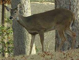
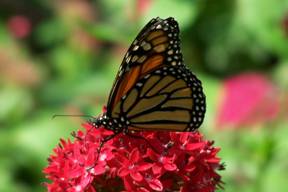
Grenada Lake is committed to managing a diversity of habitats by utilizing a variety of natural resource management techniques and tools. Sound environmental stewardship efforts help preserve our natural resources for both game and non-game species alike. These include everything from waterfowl to bluebirds, whitetail deer and quail. Grenada Lake and the surrounding area provides critical habitat for wildlife.

Management Techniques

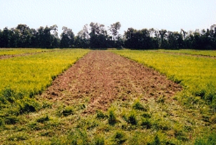
Supplemental Food Plots

Food plots are planted around the lake to help offset the destruction of habitat and provide food sources for wildlife. Strip disking is another wildlife enhancement technique used by Grenada Lake. Areas are disked in rows while leaving buffer zones which provide cover and nesting areas for wildlife.

Control Burns

Prescribed burns is a natural tool used to control unwanted plants and manage wildlife habitats. Forests fires have occurred naturally in most ecosystems for thousands of years and some vegetative areas must have controlled burns in order for them to survive.

Wildlife Management

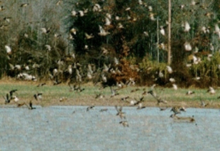
Grenada Lake, along with other agencies, such as the U.S. Fish & Wildlife Service, Mississippi Department of Wildlife, Fisheries, and Parks, and Ducks Unlimited, maintain four wildlife management areas to provide improved nesting and feeding habitats for migrating waterfowl and native wildlife species.


Wildlife Management Areas

Three wildlife management areas, which are highlighted on the location map, are operated on Grenada Lake in partnership with private, state, and federal organizations.

Grenada Waterfowl Refuge:  This 912 acre wildlife management area consists of a combination of land types including open agricultural land, beaver ponds, manmade impoundments, and bottomland hardwoods.  Hunting is not permitted in the waterfowl refuge.

Benwood Waterfowl Management Area:  This 1,400 acre wildlife management area is operated in partnership with the U.S. Fish and Wildlife Service.  Water control structures are managed to drain water and allow for planting grain crops.  Later the mature crops are flooded to provide feeding and resting areas for wintering waterfowl.  This area is closed to hunting.

Haserway Wetland Demonstration Area:  This area consists of 330 acres of wetlands, bottomland hardwoods, waterfowl food plots, and moist soil units.  The primary objective of this area is the development, restoration, and enhancement of waterfowl habitat with special emphasis on public access and environmental interpretation.  Some of the wildlife in this area includes fox, gray squirrels, white tail deer, woodpeckers, rabbits, beaver, turkey, opossums, quail, mourning doves, and numerous species of ducks.  A 100 acre green tree reservoir and two shorebird wading ponds are also located in this area.  Trails, bridges, and observation decks provide visitors with opportunities to view an assortment of wildlife.  Displays provide information about wetland habitats and wildlife species.  This area is closed to hunting.

Our wildlife biologist and natural resources rangers develop and plant approximately 120 acres in various areas around the lake to attract and enhance game species such as deer, turkey, duck, and quail.  These food plots also benefit non-game species including many songbirds.  The biologist and rangers also monitor and maintain approximately 90 bluebird boxes and 70 wood duck boxes.  There are several bald eagle nests located on Grenada Lake, which are monitored for their protection, and the maintenance of records to protect these magnificent birds.

In partnership with the Mississippi Department of Wildlife, Fisheries, and Parks our biologist and natural resource rangers operate a five acre nursery pond for the production of game fish in an effort to enhance fishing on Grenada Lake.  Each year volunteers construct approximately 700 – 800 fish shelters at our annual Fish Habitat Day allowing sportsmen the opportunity to give something back and maintain Grenada Lake as one of the premier crappie fishing lakes in the nation.


Environmental Stewardship

Grenada Lake is dedicated to the protection of our environment and natural resources. Environmentally sensitive areas are allocated to preserve scientific, ecological, cultural, and aesthetic features. No development is allowed on these lands, and public use may be subject to specified restrictions to protect these environmentally sensitive areas.


Haserway Wetland Demonstration Area is a 330-acre wetland area and became the nation's first public-use wetland demonstration area on May 26, 1993. Haserway is a direct result of the partnership between Ducks Unlimited, U.S. Fish & Wildlife Service, several local businesses, and the U.S. Army Corps of Engineers. Haserway includes a 100-acre green tree reservoir of bottomland hardwood trees, five 5-acre moist soil management areas, two 5-acre millet ponds and a 1.5 mile long interpretive trail with an opportunity to view wildlife in their natural setting.

A 404 permit is required prior to any dirt removal, ditching or dredging work being performed on government or private lands surrounding the lake. When in doubt as to whether a planned activity requires a permit, contact the Vicksburg District Regulatory Office at (601) 631-5276.